9.34.9. Virtuoso 7.1+ Geo Spatial Data type and function enhancements
As of Virtuoso 7.1+ (open source and commercial) a number of major enhancements in Geo Spatial support have been made to improve the Geometry data types and functions supported, as well as improve compliance with the emerging GeoSPARQL and OGC standards.
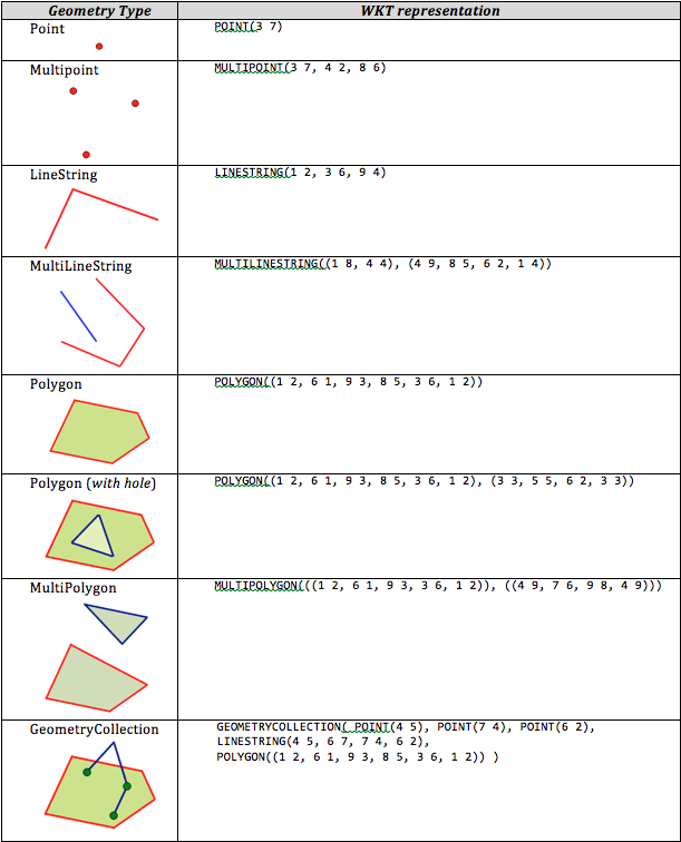
Virtuoso Geo Spatial Geometry data types and sample queries
The table below outlines the common WKT (Well Known Text) representations for several types of geometric objects used in RDF:
Figure 9.1. Geo Spatial Geometry Data Types
The following queries "counts the number of items of each type whose coordinates fall within a bounded box shape" for the various RDF geometry data types now supported by Virtuoso. The links are to live examples of the query running against the OpenLink LOD Cloud Server instance.
BOX
SELECT ?f AS ?facet COUNT(?s) AS ?cnt
FROM <http://linkedgeodata.org>
WHERE
  {
   ?s <http://www.w3.org/1999/02/22-rdf-syntax-ns#type> ?f .
   ?s <http://www.w3.org/2003/01/geo/wgs84_pos#geometry> ?p .
   FILTER(bif:st_intersects(bif:st_geomfromtext("BOX(0.3412 43.5141, 9.3412 48.0141)"), ?p))
  }
GROUP BY ?f
ORDER BY DESC(?cnt)
LIMIT 10
POLYGON
SELECT ?f AS ?facet COUNT(?s) AS ?cnt
FROM <http://linkedgeodata.org>
WHERE
  {
    ?s <http://www.w3.org/1999/02/22-rdf-syntax-ns#type> ?f .
    ?s <http://www.w3.org/2003/01/geo/wgs84_pos#geometry> ?p .
    FILTER( bif:st_intersects( bif:st_geomfromtext( "POLYGON((1 2, 6 1, 9 3, 8 5, 3 6, 1 2))" ), ?p ) )
  }
GROUP BY ?f
ORDER BY DESC(?cnt)
LIMIT 10
POLYGON WITH HOLE
SELECT ?f AS ?facet COUNT(?s) AS ?cnt
FROM <http://linkedgeodata.org>
WHERE
  {
    ?s <http://www.w3.org/1999/02/22-rdf-syntax-ns#type> ?f .
    ?s <http://www.w3.org/2003/01/geo/wgs84_pos#geometry> ?p .
    FILTER( bif:st_intersects( bif:st_geomfromtext( "POLYGON((1 2, 6 1, 9 3, 8 5, 3 6, 1 2), (3 3, 5 5, 6 2, 3 3))" ), ?p ) )
  }
GROUP BY ?f
ORDER BY DESC(?cnt)
LIMIT 10
MULTIPOLYGON
SELECT ?f AS ?facet COUNT(?s) AS ?cnt
FROM <http://linkedgeodata.org>
WHERE
  {
    ?s <http://www.w3.org/1999/02/22-rdf-syntax-ns#type> ?f .
    ?s <http://www.w3.org/2003/01/geo/wgs84_pos#geometry> ?p .
    FILTER( bif:st_intersects( bif:st_geomfromtext( "MULTIPOLYGON(((1 2, 6 1, 9 3, 3 6, 1 2)), ((4 9, 7 6, 9 8, 4 9)))" ), ?p ) )
  }
GROUP BY ?f
ORDER BY DESC(?cnt)
LIMIT 10
GEOMETRY COLLECTION
SELECT ?f AS ?facet COUNT(?s) AS ?cnt
FROM <http://linkedgeodata.org>
WHERE
  {
    ?s <http://www.w3.org/1999/02/22-rdf-syntax-ns#type> ?f .
    ?s <http://www.w3.org/2003/01/geo/wgs84_pos#geometry> ?p .
    FILTER( bif:st_intersects( bif:st_geomfromtext( "GEOMETRYCOLLECTION( POINT(4 5), POINT(7 4), POINT(6 2), LINESTRING(4 5, 6 7, 7 4, 6 2), POLYGON((1 2, 6 1, 9 3, 8 5, 3 6, 1 2)) )" ), ?p ) )
  }
GROUP BY ?f
ORDER BY DESC(?cnt)
LIMIT 10
MULTI POINT
SELECT ?f AS ?facet COUNT(?s) AS ?cnt
FROM <http://linkedgeodata.org>
WHERE
  {
    ?s <http://www.w3.org/1999/02/22-rdf-syntax-ns#type> ?f .
    ?s <http://www.w3.org/2003/01/geo/wgs84_pos#geometry> ?p .
    FILTER( bif:st_intersects( bif:st_geomfromtext( "MULTIPOINT(3 7, 4 2, 8 6)" ), ?p ) )
  }
GROUP BY ?f
ORDER BY DESC(?cnt)
LIMIT 10
LINE STRING
SELECT ?f AS ?facet COUNT(?s) AS ?cnt
FROM <http://linkedgeodata.org>
WHERE
  {
    ?s <http://www.w3.org/1999/02/22-rdf-syntax-ns#type> ?f .
    ?s <http://www.w3.org/2003/01/geo/wgs84_pos#geometry> ?p .
    FILTER( bif:st_intersects( bif:st_geomfromtext( "LINESTRING(1 2, 3 6, 9 4)" ), ?p ) )
  }
GROUP BY ?f
ORDER BY DESC(?cnt)
LIMIT 10
MULTI LINE STRING
SELECT ?f AS ?facet COUNT(?s) AS ?cnt
FROM <http://linkedgeodata.org>
WHERE
  {
    ?s <http://www.w3.org/1999/02/22-rdf-syntax-ns#type> ?f .
    ?s <http://www.w3.org/2003/01/geo/wgs84_pos#geometry> ?p .
    FILTER( bif:st_intersects( bif:st_geomfromtext( "MULTILINESTRING((1 8, 4 4), (4 9, 8 5, 6 2, 1 4))" ), ?p ) )
  }
GROUP BY ?f
ORDER BY DESC(?cnt)
LIMIT 10
Supported types of shapes
BOX, BOX2D, BOX3D, BOXM, BOXZ, BOXZM
CIRCULARSTRING
COMPOUNDCURVE
CURVEPOLYGON
EMPTY
GEOMETRYCOLLECTION, GEOMETRYCOLLECTIONM, GEOMETRYCOLLECTIONZ,
GEOMETRYCOLLECTIONZM
LINESTRING, LINESTRINGM, LINESTRINGZ, LINESTRINGZM
MULTICURVE
MULTILINESTRING, MULTILINESTRINGM, MULTILINESTRINGZ, MULTILINESTRINGZM
MULTIPOINT, MULTIPOINTM, MULTIPOINTZ, MULTIPOINTZM
MULTIPOLYGON, MULTIPOLYGONM, MULTIPOLYGONZ, MULTIPOLYGONZM
POINT, POINTM, POINTZ, POINTZM
POLYGON, POLYGONM, POLYGONZ, POLYGONZM
POLYLINE, POLYLINEZ
RING, RINGM, RINGZ, RINGZM
Not yet supported types
CIRCULARSTRINGM, CIRCULARSTRINGZ, CIRCULARSTRINGZM
COMPOUNDCURVEM, COMPOUNDCURVEZ, COMPOUNDCURVEZM
CURVE, CURVEM, CURVEZ, CURVEZM
CURVEPOLYGONM, CURVEPOLYGONZ, CURVEPOLYGONZM
GEOMETRY, GEOMETRYZ, GEOMETRYZM
MULTICURVEM, MULTICURVEZ, MULTICURVEZM
MULTIPATCH
MULTISURFACE, MULTISURFACEM, MULTISURFACEZ, MULTISURFACEZM
POLYHEDRALSURFACE, POLYHEDRALSURFACEM, POLYHEDRALSURFACEZ,
POLYHEDRALSURFACEZM
POLYLINEM
SURFACE, SURFACEM, SURFACEZ, SURFACEZM
TIN, TINM, TINZ, TINZM
Virtuoso Geo Spatial geometry functions
The following Virtuoso Geo Spatial geometry functions are available for use in both SQL and RDF Geo Spatial
queries. The listed functions are built-in SQL functions. As all built-in functions of Virtuoso, geo-specific
functions can be called from SPARQL with prefix bif:
. For example:
bif:earth_radius()
etc.
-
earth_radius(): returns geom.mean of radius of Earth in kilometers, 6367.43568 -
haversine_deg_km (lat1, long1, lat2, long2): returns distance between two points on Earth sphere, adjusting radius of sphere to latitudes. -
dist_from_point_to_line_segment (Xpoint,
          	Ypoint, Xsegment1, Ysegment1,Xsegment2, Ysegment2)
: returns the distance between a point and a segment on a plane. -
st_point: returns a point with given coordinates in default SRID. z and/or m may be missing or equal to NULL, indicating the absence of co-ordinate. -
st_linestring (item1, item2,..., itemN): returns a linestring in default SRID, the coordinates of vertices are specified by arguments that are points, 2-, 3- or 4-item vectors of coordinates, linestrings, arcstrings or vectors of the above mentioned values. Repeating vertices are automatically removed, except the case of repeating vertices in the middle of a linestring/arcstring argument. -
st_x(): returns X or longitude of a point. -
st_y(): returns X or longitude of a point. -
ST_YMax (shape): return boundaries of a bounding box around a shape. Bounding boxes around arcs are calculated in assumption that no one arc is longer than a half of full circle. -
st_intersects (shape1, shape2 [, proximity]): checks whether two shapes intersect or some of its points are within the specified proximity. Current version is not complete and does not support arcs of all sorts and rings of polygons, this is fixed in the next release. -
st_may_intersect (shape1, shape2 [, proximity]): checks whether bounding boxes of two shapes intersect or some of its points are within the specified proximity. This is much faster than fullst_intersects()check (actually that is the initial part ofst_intersects()execution) -
st_within (needle_shape, haystack_shape [, proximity]): checks whetherhaystack_shapecontains theneedle_shape. If proximity is specified, it is treated as an extra wide border aroundhaystack_shape. In current version, only a combination of bounding box and a point is supported, the functionality will be extended in the next release. -
st_distance (shape1, shape2): returns the distance in units of plane or in kilometers on sphere. -
isgeometry (v): returns whether the given v is a spatial object. -
st_astext (shape): returns EWKT representation of a shape. -
ST_SRID (shape): returns SRID of shape's spatial reference system or 0 for shape on plane. -
ST_SetSRID (shape, new_srid): replaces the SRID of a shape but does not transform the shape or its coordinates from old SRID to a new one. -
st_geomfromtext (ewkt_text): Parses the string and returns the corresponding geometry. -
st_ewkt_read (ewkt_text): Parses the giwen text as a EWKT and returns the parsed shape. -
http_st_ewkt (shape, ses): Writes a EWKT representation of a shape to the given session, a fast replacement for -
http_st_dxf_entity (shape, attrs, ses): writes a DXF (Data Exchange Format) representation of shape into the given output session.Attrs is a vector of arbitrary DXF properties in form (tag1, value1, tag2, value2...) where tags are integer codes according to DXF specification, related values are not validated and printed to the session as is. Current version does not support ARCSTRINGs, CURVEs and CURVEPOLYGONs. If shape is null, the function returns without writing anything to the shape. -
st_get_bounding_box (shape): returns BOX2D that is a bounding box of a shape. -
GeometryType (shape): returns EWKT type name of a shape. -
ST_NumGeometries (shape): returns number of members of a MULTI... or ...COLLECTION shape, 1 for other sorts of shapes. -
ST_GeometryN (shape, idx): Given a 1-based index of a member of a MULTI... or ...COLLECTION shape, returns the member. -
ST_ExteriorRing (polygon_shape): Returns an external (the very first) ring of a polygon. -
ST_NumInteriorRings (polygon_shape): returns number of interior rings of the given polygon, NULL if shape is not a polygon. -
ST_InteriorRingN (polygon_shape, idx): Given a 1-based index of an interior ring of a polygon, returns the ring. Wrong index is not reported as an error and NULL is returned. -
st_get_bounding_box_n (shape, idx): Given a 1-based index of a member of a MULTI... or ...COLLECTION shape, returns the bounding box of a member. This is a fast equivalent of -
ST_Translate (shape, dX, dY [, dZ]): returns a copy of a shape with all coordinates shifted by the provided dX, dY and dZ. -
ST_TransScale (shape, dX, dY, Xfactor, Yfactor): returns a copy of a shape with all coordinates shifted by the provided dX, dY and then multiplied by Xfactor and Yfactor. In current version, differente values for Xfactor and Yfactor will result in distorted arcs. -
st_transform_by_custom_projection (shape, algorithm_id, ...): Performs a custom projection of shape, using the specified algorithm and algorithm-specific arguments. Current version supports only one algorithm,st_transform_by_custom_projection (shape, 'OLAEAPS', long_of_center, lat_of_center)for Oblique Lampert Azimuthal Equal-Area Projection System with the specified center point. -
ST_Transform (shape, deST_SRID, [orig_proj4_string, dest_proj4_string]): Transforms the given shape from its current spatial reference system to one specified bydeST_SRID. Two optional arguments are for "cheating": the SRID of the resulting shape is set todeST_SRIDbut the conversion is done by proj4 usingorigin_proj4_stringfor projection of original shape anddest_proj4_stringfor the result. Iforig_proj4_stringordest_proj4_stringargument is passed but is NULL instead of string, the projection corresponding to original or destination SRID is used.ST_Transformis provided by a separate plugin named proj4, as described below. When the plugin is loaded, functions likest_intersects()support pairs of arguments with different SRIDs by converting coords of second argument into the system of the first one, as required by OGC and GeoSPARQL. -
postgis_proj_version(): Returns the version of proj4 in use, as a string, for compatibility with PostGIS.
proj4 plugin
The Virtuoso proj4 hosted plugin module is required for performing transformation between different
co-ordinates systems using the ST_Transform()
function. The plugin is based on
Frank Warmerdam's proj4
library and it's practical to have
the proj4 package installed on every box of Virtuoso cluster, even if the build is performed on single machine
or on different location at all. The reason is that the plugin should load data about coordinate systems to
work and the simplest way to get the right data from a high-quality source is to use the package.
Compiling open source proj4 plugin
The proj4 is currently available in the default develop/7 branch of the "Virtuoso Open Source " git repository and can be build as follows:
git clone https://github.com/openlink/virtuoso-opensource.git
cd virtuoso-opensource
./autogen.sh
export CFLAGS="-msse4.2 -DSSE42"
./configure
make -j 24
make install
Note first the "proj.4" library must be installed on the system and can be proj.4 download area, which the configure script will detect the installation of enabling the proj4 plugin library to be built in ~/libsrc/plugin/.libs:
ls libsrc/plugin/.libs/proj4*
libsrc/plugin/.libs/proj4.a
libsrc/plugin/.libs/proj4.la
libsrc/plugin/.libs/proj4.lai
libsrc/plugin/.libs/proj4_la-import_gate_virtuoso.o
libsrc/plugin/.libs/proj4_la-sql_proj4.o
libsrc/plugin/.libs/proj4_la-proj4_plugin.o
libsrc/plugin/.libs/proj4.so
libsrc/plugin/.libs/proj4.ver
Installation and Configuration of proj4 plugin
When the plugin (proj4.so) is built, it needs to be added to the [Plugins] section of Virtuoso configuration file (virtuoso.ini or the like), also on every node of a cluster:
[Plugins]
LoadPath = ./plugins
Load2    = plain, proj4
If everything is fine then the virtuoso.log file will contain something like the following lines after the next startup:
21:30:10 { Loading plugin 1: Type `plain', file `shapefileio' in `.'
21:30:10   ShapefileIO version 0.1virt71 from OpenLink Software
21:30:10   Shapefile support based on Frank Warmerdam's Shapelib
21:30:10   SUCCESS plugin 1: loaded from ./plugins/shapefileio.so }
21:30:10 { Loading plugin 2: Type `plain', file `proj4' in `.'
21:30:11   plain version 3208 from OpenLink Software
21:30:11   Cartographic Projections support based on Frank Warmerdam's
proj4 library
21:30:11   SUCCESS plugin 2: loaded from ./plugins/proj4.so }
21:30:11 OpenLink Virtuoso Universal Server
21:30:11 Version 07.10.3208-pthreads for Linux as of Mar 31 2014
...
21:30:28 PL LOG: Initial setup of DB.DBA.SYS_PROJ4_SRIDS data from
files in "/usr/share/proj"
21:30:30 PL LOG: DB.DBA.SYS_PROJ4_SRIDS now contains 6930 spatial
reference systems
...
21:30:32 Server online at 1720 (pid 9654)
To store descriptions of coordinate systems, the plugin creates a table:
create table DB.DBA.SYS_PROJ4_SRIDS (
 SR_ID integer,
 SR_FAMILY varchar not null,
 SR_TAG varchar,
 SR_ORIGIN varchar not null,
 SR_IRI IRI_ID_8,
 SR_PROJ4_STRING varchar not null,
 SR_WKT varchar,
 SR_COMMENT varchar,
 SR_PROJ4_XML any,
 primary key (SR_ID, SR_FAMILY) )
;
and fills it with data from files epsg, esri, esri.extra, nad83 and nad27 of directory /usr/share/proj. Note these files must exist in the /usr/share/proj directory otherwise a message will be reported in the log file indicated the file could not be found. Every row of the table is identified with name of "family" of coordinate systems and an integer SRID. Different sources may assign same SRID to different reference systems, however descriptions of well-known systems match exactly or the difference is not noticeable for any practical application.
The loading process uses family names 'EPSG', 'ESRI', 'NAD83' and 'NAD27'. When the ST_Transform()
searches for a coordinate system that corresponds to a given SRID then it returns first record found while checking
the following families in the following order: 'PG', 'EPSG', 'ESRI','NAD83', 'NAD27'. Thus it is practical to put
all custom definitions in 'PG' family, thus they will get the highest priority.
A sample EPSG file containing the mapping for the proj.4 EPSG:4326 coordinate system is:
$ cat /usr/share/proj/epsg
<4326>+proj=longlat +ellps=WGS84 +datum=WGS84 +no_defs<>
SQL> SELECT * FROM DB.DBA.SYS_PROJ4_SRIDS;
SR_ID             SR_FAMILY          SR_TAG    SR_ORIGIN              SR_IRI    SR_PROJ4_STRING                                    SR_WKT    SR_COMMENT   SR_PROJ4_XML
INTEGER NOT NULL  VARCHAR NOT NULL   VARCHAR   VARCHAR NOT NULL       VARCHAR   VARCHAR NOT NULL                                   VARCHAR   VARCHAR      VARCHAR
_______________________________________________________________________________

4326              EPSG               4326      /usr/share/proj/epsg   NULL      +datum=WGS84 +ellps=WGS84 +no_defs +proj=longlat             NULL         NULL

1 Rows. -- 0 msec.
SQL>
There are two procedures are available for loading more co-ordinate systems:
-
DB.DBA.PROJ4_LOAD_SYS_SRIDS: it is called at server startup if the proj4 plugin is loaded:DB.DBA.PROJ4_LOAD_SYS_SRIDS ( in projdir varchar := '/usr/share/proj', in only_if_empty_table integer := 0 )
-
DB.DBA.PROJ4_LOAD_INIT_FILE: it is lower-level procedure:DB.DBA.PROJ4_LOAD_INIT_FILE ( in path varchar, in _sr_family varchar )
The main part of DB.DBA.PROJ4_LOAD_SYS_SRIDS()
is a sequence of:
DB.DBA.PROJ4_LOAD_INIT_FILE (projdir || '/epsg', 'EPSG');
DB.DBA.PROJ4_LOAD_INIT_FILE (projdir || '/esri', 'ESRI');
DB.DBA.PROJ4_LOAD_INIT_FILE (projdir || '/esri.extra', 'ESRI');
DB.DBA.PROJ4_LOAD_INIT_FILE (projdir || '/nad83', 'NAD83');
DB.DBA.PROJ4_LOAD_INIT_FILE (projdir || '/nad27', 'NAD27');
Rows with same SRID but different SR_FAMILY
may exist in the table, however only one
projection per SRID is used and SR_FAMILY
defines the priority. The internal search query
for projection by SRID is:
SELECT COALESCE
   (
     ( SELECT SR_PROJ4_STRING FROM DB.DBA.SYS_PROJ4_SRIDS WHERE SR_ID=:0 AND SR_FAMILY='PG'),
     ( SELECT SR_PROJ4_STRING FROM DB.DBA.SYS_PROJ4_SRIDS WHERE SR_ID=:0 AND SR_FAMILY='EPSG'),
     ( SELECT SR_PROJ4_STRING FROM DB.DBA.SYS_PROJ4_SRIDS WHERE SR_ID=:0 AND SR_FAMILY='ESRI'),
     ( SELECT SR_PROJ4_STRING FROM DB.DBA.SYS_PROJ4_SRIDS WHERE SR_ID=:0 AND SR_FAMILY='NAD83'),
     ( SELECT SR_PROJ4_STRING FROM DB.DBA.SYS_PROJ4_SRIDS WHERE SR_ID=:0 AND SR_FAMILY='NAD27')
   )
so for ST_Transform()
function 'PG' overrides everything else, EPSG is the next highest priority,
then ESRI, NAD83 and NAD27. However custom queries and procedure may select whatever they please, including sr families
not listed here or strings from other tables etc., and feed projection strings directly to ST_Transform()
.
The co-ordinate systems can also be updated by direct manipulations on DB.DBA.SYS_PROJ4_SRIDS table
(the table it is readable for public and writable for DBA only). When the table is edited, call function
"Proj4 cache_reset()
" to prevent SQL runtime from using previously prepared projections that might become
obsolete after changes in the table. Note that proj4 projections are for normalized data in radians whereas Virtuoso
stores shapes using numbers that come from WKT, i.e. they're latitudes and longitudes in degrees for almost all cases.
The proj4 plugin automatically applies RAD_TO_DEG
multiplier before conversion and/or
RAD_TO_DEG
multiplier after conversion when source and/or destination coordinate systems are
latitude-longitude or geocentric. Even if this conversion is done automatically, you should remember that it
happens, for the following reason. Many "how-to" instructions for spatial data sets contain paragraphs like
"how to convert these data to WGS-84" and sample C/C++ code contains transformations like
{ x *= RAD_TO_DEG; y *= RAD_TO_DEG; }
. These transformations will probably be redundant in the
corresponding Virtuoso/PL code whereas proj4 strings can be used unchanged and passed as 3rd and 4th arguments of
ST_Transform()
function. If degrees-to-radians conversion is made twice then the data can be calculated
as if the shape is located in a totally different place of ellipsoid. If the post-transformation radians-to-degrees
conversion is also made twice, the resulting shape may look like the real one but coordinates may be tens kilometers
away from correct values.
ST_Transform() Example
Below are some example uses of the ST_Transform()
function to transform some of the sample
coordinate systems load into Virtuoso:
SQL> SELECT * FROM DB.DBA.SYS_PROJ4_SRIDS;
SR_ID              SR_FAMILY          SR_TAG    SR_ORIGIN              SR_IRI    SR_PROJ4_STRING                                                                                                                                                                         SR_WKT    SR_COMMENT   SR_PROJ4_XML
INTEGER NOT NULL   VARCHAR NOT NULL   VARCHAR   VARCHAR NOT NULL       VARCHAR   VARCHAR NOT NULL                                                                                                                                                                        VARCHAR   VARCHAR      VARCHAR
_______________________________________________________________________________

2005               EPSG               2005      /usr/share/proj/epsg   NULL      +ellps=clrk80 +k=0.9995000000000001 +lat_0=0 +lon_0=-62 +no_defs +proj=tmerc +units=m +x_0=400000 +y_0=0                                                                                          NULL         NULL
2249               EPSG               2249      /usr/share/proj/epsg   NULL      +datum=NAD83 +ellps=GRS80 +lat_0=41 +lat_1=42.68333333333333 +lat_2=41.71666666666667 +lon_0=-71.5 +no_defs +proj=lcc +to_meter=0.3048006096012192 +x_0=200000.0001016002 +y_0=750000             NULL         NULL
4326               EPSG               4326      /usr/share/proj/epsg   NULL      +datum=WGS84 +ellps=WGS84 +no_defs +proj=longlat                                                                                                                                                  NULL         NULL

3 Rows. -- 1 msec.
SQL> SELECT ST_Transform (st_geomfromtext ('POLYGON((-16 20.25,-16.1 20.35,-15.9 20.35,-16 20.25))'), 1, '+proj=latlong +ellps=clrk66', '+proj=merc +ellps=clrk66 +lat_ts=33');
unnamed
VARCHAR NOT NULL
_______________________________________________________________________________

SRID=1;POLYGON((-1495284.211473 1920596.789917,-1504629.737795 1930501.842961,-1485938.685152 1930501.842961,-1495284.211473 1920596.789917))

1 Rows. -- 0 msec.
SQL> SELECT ST_AsText(ST_Transform(ST_GeomFromText('POLYGON((743238 2967416,743238 2967450, 743265 2967450,743265.625 2967416,743238 2967416))',2249),4326)) AS wgs_geom;
wgs_geom
VARCHAR NOT NULL
_______________________________________________________________________________

POLYGON((-71.177685 42.390290,-71.177684 42.390383,-71.177584 42.390383,-71.177583 42.390289,-71.177685 42.390290))

1 Rows. -- 1 msec.
SQL>